
A HAND-COLOURED MAP OF IRELAND BY FADEN,
WHOSE ‘MAPS WERE REPUTED THE FINEST BEING ENGRAVED ANYWHERE IN THE WORLD’
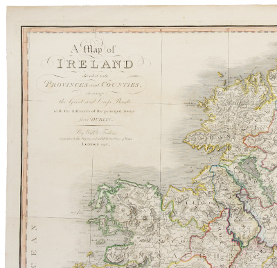
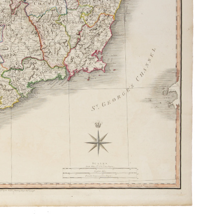
FADEN, William. ‘A Map of Ireland Divided into Provinces and Counties, Shewing the Great and Cross Roads with the Distance of the Principal Towns from Dublin’. London: William Faden, 17 September 1798.
Engraved map by and after Faden on laid paper watermarked ‘JBates’, hand-coloured in outline (platemark: 715 x 555mm; sheet: 755 x 572), folded vertically for binding, traces of guard on verso. Annotated and numbered on the verso ‘Irelande 7’ in a contemporary hand. (Very light offsetting, slightly creased, short marginal tear, small candle-wax mark.) A very good example with contemporary hand colouring.
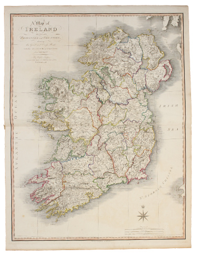
First edition. The engraver and cartographer William Faden (1749-1836) served an apprenticeship with the London engraver James Wigley before going into partnership with the family of the deceased map maker Thomas Jefferys as ‘Faden and Jefferys’. During ‘the years of the American wars Faden came to prominence with maps and atlases of considerable historical note’ (ODNB), and following an inheritance from his father in 1783, Faden bought out the remaining Jefferys interest and took sole control of the business. In the same year Faden was appointed ‘Geographer in Ordinary’ to King George III and the Prince of Wales (the engraved compass rose on the present map has the latter’s heraldic badge above it). ‘Systematic in the acquisition of the best available maps, Faden developed the most competent cartographic service of the period. His was an international concern, in contact with map makers throughout Europe. He supplied government departments and commissioned fresh surveys. A gold medallist of the Society of Arts in 1796, his activities foreshadowed the emergence of national cartographic agencies. He brought out the first published Ordnance Survey map, An Entirely New & Accurate Survey of the County of Kent (1801). Some of his plates were likewise adopted as official Admiralty maps. When he moved at this time to larger premises at no. 5 Charing Cross, his maps were reputed the finest being engraved anywhere in the world’ (op. cit.).
‘A Map of Ireland Divided into Provinces and Counties’ was included in Faden’s General Atlas and was also issued as a folding map laid down on linen. As Tooley notes, ‘Faden apparently did not publish standard atlases with printed titles, but made up collections to suit his customers’ requirements, and bound them up without title or list of contents […]. The number may vary from 20 to 60’ (R.V. Tooley, Maps and Map Makers (1952), p. 52). In the Library of Congress copy of the General Atlas this map was the seventh in the volume, and the guard on the verso of this map together with the manuscript inscription ‘Irelande 7’ suggest that this map was extracted from a copy of the atlas with a similar order and composition to that of the Library of Congress copy, apparently from the library of a French (or francophone) owner.
P.L. Phillips and C.E. LeGear, A List of Geographical Atlases in the Library of Congress, 6013, no. 7; T.R. Smith and B.L. Thomas, Maps of the 16th to 19th Centuries in the University of Kansas Libraries, 213.
£295
· · · · · · · · · · · · · · · · · · · · · · · · · ·
Our Terms & Conditions apply.